I’ve been lucky enough to walk the Célé Valley route a few times now, and I always struggle with the last chunk of it, between Saint-Cirq-Lapopie and Cahors. If you follow the “official” GR36 along the way, faithfully and completely, it’ll run something like 35 to 39km, depending upon whether you take the riverside fork or the inland fork to the Mont Saint-Cyr viewpoint. The other thing about that “official” route is that, after Bouziès, there is zero food along the path (though the Arcambal bakery isn’t a great hardship), nor many accommodation options (though Pasturat’s gite is great). You can detour to Saint-Géry and Vers, but the latter in particular is a hassle, spanning 2km each way.
It’s an awkward distance, especially given the lack of stuff along the way, and–certainly in my case–the likelihood of some shorter stages preceding it in the Célé Valley. I don’t really want to do it in two days, but 35-39km with little food is a tough sell for most.
Over the years, I’ve poked around on this stage, finding a variety of different shortcuts and longcuts, but only on my most recent excursion last month did I put together what I suspect will be my preferred method moving forward, one I can enthusiastically recommend, with a couple of caveats.
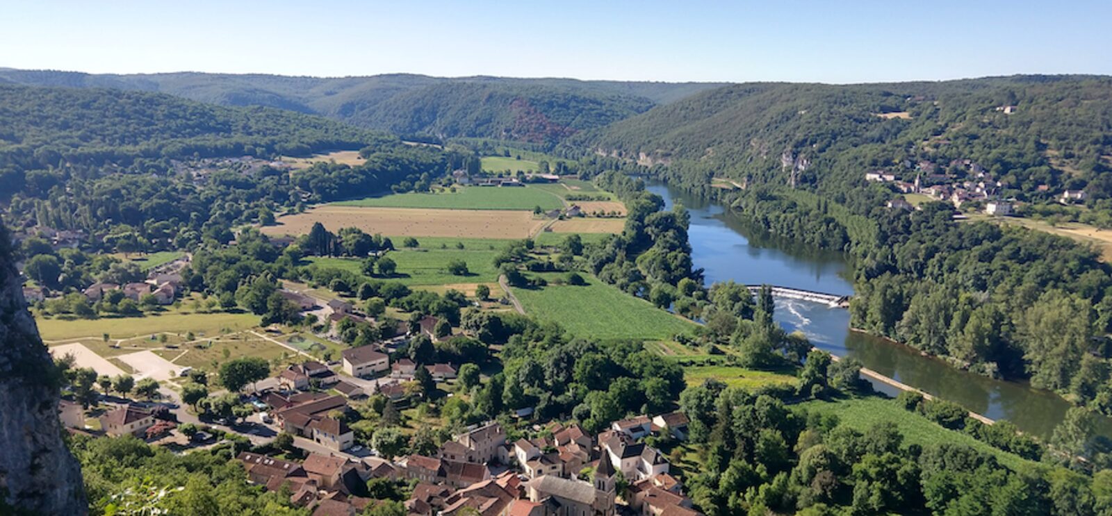
In a nutshell, this route is 29.8km from Saint-Cirq-Lapopie to Cahors. It passes through Saint-Géry and Vers, both of which have bakeries and grocery stores. It’s the shortest way you can make this walk and the route with the most food and facilities.

Main route-finding notes:
- Follow the GR36 out of Bouziès, down to the riverside track. When the GR36 turns left, under a train trestle, keep going straight on the track
- Note: if you aren’t carrying trekking poles, you will find it helpful to have a sturdy stick for later on, and this is the best area to snag one
- Just before passing under a train bridge that crosses the Lot, turn left and scramble uphill to join the bridge. This is one of two dicey issues to manage on this route
- The other dicey issue kicks in on the other side of the bridge. This next stretch is chronically overgrown with brambles (this is where that stick comes in). My approach is generally to follow the bridge until it reaches the D662 (minor highway), whomping brambles out of the way as I go, and then to descend down the right side. This can be slow-going. Those who are less confident in their footing might want to employ the “butt scoot” method downhill. Once you’ve completed this, though, the worst of the walk is behind you
- Follow the D662 into Saint-Géry, past the bakery, grocery, and then turning right immediately before the church. Note the sign for “site d’escalade.” Near the end of this road, watch for a similar sign, calling for a turn onto a footpath. (This was the missing piece for me, the trail that “closed the gap” between Saint-Géry and Vers, and I was hooting with excitement when I found it to be workable this summer.)
- A steep climb follows, onto the cliff overlooking Saint-Géry. This is the only genuinely strenuous part of the walk, and it will feel familiar to those who just finished the Célé Valley. You’ll ascend first to the cliff face, then turn left and continue climbing to the top. When you emerge on a dirt road at the top, turn right. Epic views will start showing up to your right
- Take the next left onto another dirt road. At this point, you’ll spot yellow horizontal stripes. These waymarks, indicating a local pedestrian track, will lead you into Vers
- Once in Vers, descend to the lovely park at the intersection of the Lot and Vers Rivers. Bask in the glory
- Cross the pedestrian bridge and continue south along the west side of the Lot. Keep left around the Église Notre-Dame de Velles. Eventually, that dirt road will loop right and join the D653 highway. Turn left
- When you intersect train tracks soon after, turn left onto the tracks. Continue straight onto a retired train bridge over the Lot
- Continue straight after the bridge, ignoring a steep trail descending off the right side. Just keep going straight along the footpath. In time, you’ll merge with the GR36, and from there it’s smooth sailing
The downsides of this walk are the brambles on the train bridge, the tricky up-and-down to/from the bridge leading to Saint-Géry, and the chunk of highway walking (with limited shoulder) into Saint-Géry. I love getting to see the Lot from atop the cliffs over Saint-Géry, though, and I’m even more ecstatic about finding a way to fit Vers into a single-day walk from Saint-Cirq (or Cabrerets) to Cahors. It’s such a beautiful village, and I think a lot of people miss out on it.
Anyway, this was already the most complicated stage in the book, with an abundance of route options. Why not make it more complicated? At the same time, though, if you’re comfortable with the brambles and the tricky up-and-down, I can recommend this wholeheartedly.
2 thoughts on “Walking from Saint-Cirq-Lapopie to Cahors”
Comments are closed.


Would you advise cycling the Camino del Nortè by any chance? When would be the time? Are the walking and cycling paths the same or different—I wonder? Thank you. Stay safe ;^o
I need to lead with a disclaimer that I’m not a cyclist, so my feedback on this question lacks that firsthand experience. The second disclaimer is that the answer to this question varies widely based on the kind of bike you want to ride. If you prefer a road bike, then you’re definitely splitting with the “official” Norte in quite a few places. If you’re on a mountain bike but not comfortable with steeper descents on cobblestones, then you’ll also need to diverge more often than someone who is fine with those circumstances.
A few years ago, someone asked me about this, and I offered some quick thoughts on the viability of each stage on a mountain bike:
Stage 1: I’d probably take the highway from Santuario de Guadalupe to Pasajes. Very minor adjustment and still beautiful. The last ascent to Santuario is on dirt tracks that are uphill and can have loose rock. I think it’s doable, but if you’re worried about that on the first day, you could go around via Hondarribia
Be sure to go left on the other side of the boat dock in Pasajes
Stage 2: No issues, though you’ll want to take the cobble-stone descent to Orio very carefully
Stage 3: I’d follow the highway between Zarautz and Getaria. Stay on the official Camino after Zumaia (ignoring the GR alternate). You could bypass the cobblestone descent into Deba by following the road around
Stage 4: A tough ride with all of the uphill, but good trails for bikes
Stage 5: From Zenarruza to Munitibar, I’d follow the highway, as there are some new wooden walkways/staircases that will make the trail harder
Stage 6: The ascent from Zamudio to Monte Avril might be tough, but I think it’s navigable on a bike. The descent into the Plaza de Unamuno in Bilbao follows a long staircase, but it’s easy to ride around
Stage 7: I’d definitely follow the East Nervión variant to Portugalete
Stage 8: The hardest part is going up the stairs from Pobeña. Totally worth it, though, and should be easy from there
Stage 9: Probably best to take the highway option today. The final descent into Laredo has a bunch of stairs, but you can follow the road around
Stage 10: Avoid the hill crossing after Playa de Berria. Follow the road inland and then take the highway around the hill, then on to Noja
Stage 11: Definitely do the official route along the coast. You’ll have to deal with some beach riding at the end or take an earlier detour inland on a paved road, but it’s totally worth it
Stage 12: Either route should be fine
Stage 13: Should be fine. I think the new coastal option through Cóbreces is probably superior on a bike
Stage 14: No issues
Stage 15: I wouldn’t take the new offroad option after La France, but instead stay on the paved road through Buelna and Pendueles. I would take the GR E-9 option after Andrín, though. It’s a hard-packed dirt/gravel road
Stage 16: Mostly fine, though there’s a bike alternate after Piñeres de Pria to wrap around a tricky ascent to the Casa Rectoral. I think the final approach to Ribadesella has some steps, so you may just want to follow the highway for that last bit
Stage 17: I think it’ll be ok, though the part uphill out of Vega is on a sandy beach track that might be rough. Once you clear that, though, I think the trail is probably fine and it’s certainly a great pleasure
Stage 18: No issues
Stage 19: No issues
Stage 20: No issues
Stage 21: Some of the offroad jaunts can be steep and rocky. I think you’d be ok on most, but you may prefer sticking with the N-632 through here. Very little traffic and pleasant
Stage 22: The final descent to Luarca has some steps, but easy to navigate around
Stage 23: No issues
Stage 24: No issues. Take the coastal option
After that… there are a few days where new, higher-level variants have been added. It’s easier to stay lower level, but the higher level options are certainly viable on mountain bikes